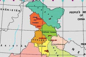
The government released the maps of newly created Union Territories of Jammu and Kashmir, and Ladakh and the map of India depicting nine UTs and 28 states

Newly carved Union Territories
New Delhi: India has got a new map. The Centre has notified geographical boundaries of newly carved Union Territories (UTs) of Jammu and Kashmir and Ladakh. According to today’s notification, the Union Territory of Jammu and Kashmir will constitute all districts of the former state except Kargil and Leh, which will form the Union Territory of Ladakh.
ADVERTISEMENT
The government released the maps of newly created Union Territories of Jammu and Kashmir, and Ladakh and the map of India depicting nine UTs and 28 states. On the recommendation of the Parliament, the President Ram Nath Kovind effectively dismantled Article 370 of the Indian Constitution and gave assent to the Jammu and Kashmir Reorganisation Act, 2019.
Under the leadership of Prime Minister Narendra Modi and supervision of Union Home Minister Amit Shah, the erstwhile state of Jammu and Kashmir has been reorganised as the new Union Territory of Jammu and Kashmir and the new Union Territory of Ladakh on October 31, 2019, a statement of the Ministry of Home Affairs (MHA) said.
Catch up on all the latest Crime, National, International and Hatke news here. Also download the new mid-day Android and iOS apps to get latest updates
This story has been sourced from a third party syndicated feed, agencies. Mid-day accepts no responsibility or liability for its dependability, trustworthiness, reliability and data of the text. Mid-day management/mid-day.com reserves the sole right to alter, delete or remove (without notice) the content in its absolute discretion for any reason whatsoever
 Subscribe today by clicking the link and stay updated with the latest news!" Click here!


