shot-button
Lake Levels Lake Levels
Home > Mumbai > Mumbai News > Article > Depression over Arabian Sea likely to intensify in the next 12 hours says Indian Meteorological Department

Depression over Arabian Sea likely to intensify in the next 12 hours, says Indian Meteorological Department

Updated on: 06 June,2023 06:23 PM IST  |  Mumbai
Dipti Singh | dipti.singh@mid-day.com

The cyclonic storm-'Biparjoy', a name given by Bangladesh, is the first pre-monsoon storm of the year in the Arabian Sea

Depression over Arabian Sea likely to intensify in the next 12 hours, says Indian Meteorological Department

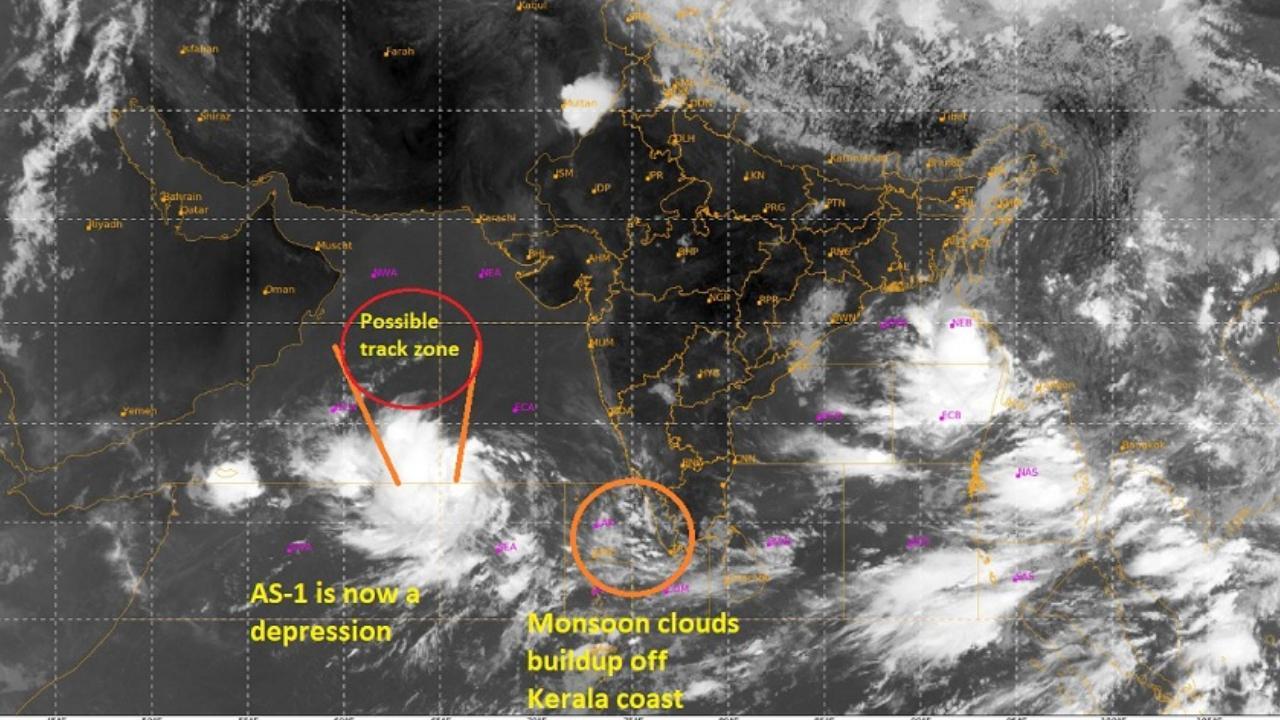
Satellelite image. Pic/Vagaries of weather

The depression over the southeast Arabian Sea, which is delaying the onset of monsoon over India, is moving roughly northward and intensifying into a cyclonic storm over the course of the next twelve hours, according to a forecast issued by the India Meteorological Department (IMD).


The IMD's Bulletin stated that the storm has a potential to impact the monsoon as it approaches the Kerala coast.


"Under the influence of cyclonic circulation over the Southeast Arabian Sea, a Low-Pressure area had formed over the same region at 5.30 pm (IST) on June 5, 2023, and the associated cyclonic circulation extends upto mid-tropospheric levels," the IMD bulletin stated.


The southwest monsoon normally sets in over Kerala on June 1, with a standard deviation of about seven days. This year, in the month of May, IMD had said that the monsoon may arrive in Kerala by June 4, with a model error of four days.

However, the monsoon missed its onset date in Kerala on Sunday with the Indian Meteorological Department. Anticipating a further delay of 3 to 4 days. This will further delay the onset of monsoon in Mumbai and other parts of Maharashtra, leading to sweltering and stuffy nights to continue until the monsoon sets in, the meteorologists have said.

"With the developing system, the cyclone will suck up all the moisture from around the Konkan coast. After the system moves away, the winds will reorganize in a week's time, making conditions favourable for rain. So according to me the probability of a monsoon now would be around or after June 15," said Rajesh Kapadia of Vagaries of Weather, a popular private weather blog.

Talking about the developing cyclonic storm, which will be named Biparjoy Sushma Nair, a scientist with IMD’s regional meteorological center at Colaba said, "The depression over the southeast Arabian Sea moved nearly northward with a speed of 11 kmph and lay centre at 0830 am (IST) today, June 6, 2023, over the same region near latitude 11.5°N and longitude 66.0°E, about 950 km west-southwest of Goa, 1100 km southwest of Mumbai, 1190 km south-southwest of Porbandar, and 1490 km south of Karachi. It is likely to move nearly northward and intensify into a cyclonic storm over the east-central Arabian Sea and adjoining southeast during the next 12 hours."

Elaborating further about the developing system, Skymet Weather,r a private weather forecasting agency said: " The depression is expected to become a tropical storm in the next 24 hours. Depression is moving in favourable environmental conditions with very warm sea surface temperature and low vertical wind shear. The potential for a cyclonic storm in the next 24 hours is rather high.  The weather system is likely to move northward, keeping a safe distance from the coast for the next 24 hours."

The meteorologists from Skymet said, "Tropical storm Biparjoy will be a slow-moving system and is expected to reach abeam Mumbai on Saturday or Sunday, remaining deep over the ocean waters. Though these storms are notorious for defying track and intensity, but it is likely to remain over the open waters of the Arabian Sea for the next 3 days. The tropical storm will be kept under close observation from hereon. Such monsters do have a history of threatening the Gujarat Coast or recurve to scare Pakistan and Makran Coast."

According to Vagaries of weather, Low wind shear, and very high sea surface temperature (SST) of 31 °C -32°C will favour the intensification of AS-1 into a strong cyclone...may further reach extremely Severe Cyclone Intensity over the next three days (equivalent to category 3 hurricane intensity approximately), Vagaries of weather predicted.

"Exciting news! Mid-day is now on WhatsApp Channels Subscribe today by clicking the link and stay updated with the latest news!" Click here!

Register for FREE
to continue reading !

This is not a paywall.
However, your registration helps us understand your preferences better and enables us to provide insightful and credible journalism for all our readers.

Mid-Day Web Stories

Mid-Day Web Stories

This website uses cookie or similar technologies, to enhance your browsing experience and provide personalised recommendations. By continuing to use our website, you agree to our Privacy Policy and Cookie Policy. OK