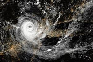
A National Disaster Response Force (NDRF) team has arrived in Ichchapuram in Andhra Pradesh.

Bhubaneswar (Odisha): The "extremely severe" cyclone Fani is about 450 km from Puri and likely to cross the Odisha coast tomorrow afternoon, the India Meteorological Department (IMD) said on Thursday.
ADVERTISEMENT
"The extremely severe cyclonic storm Fani over west central Bay of Bengal moved north-northeastwards with a speed of about 15 kmph and lay centred at 0530 hrs IST of May 2 over west central Bay of Bengal about 450 km south-southwest of Puri (Odisha), 230 km south-southeast of Vishakhapatnam (Andhra Pradesh) and 650 km south-southwest of Digha (West Bengal)," the IMD said in its bulletin.
According to the weather office, the storm is very likely to move north-northeastwards and cross the Odisha Coast between Gopalpur and Chandbali, around Puri, during May 3 afternoon with a maximum wind speed of 170-180 kmph.
The IMD has advised fishermen not to venture into sea along and off the Odisha coast till May 4. The sea condition will remain "phenomenal" in west central Bay of Bengal and off the north Andhra Pradesh coast till tomorrow and northwest Bay of Bengal off Odisha and West Bengal till May 4, it said.
The Met office said that sea conditions are likely to be very rough to high off north Tamil Nadu, Puducherry, along and off south Andhra Pradesh coasts till May 4.
It has said that the storm may cause damage to kutcha houses, weak structures, standing crops and plantations.
The bulletin suggested evacuation of people from coastal areas and appropriate regulation of rail and road traffic. It asked people in areas expected to be affected to remain indoors and termed as "unsafe" movement in motor boats and small ships.
"Heavy to very heavy rainfall is very likely at a few places in the districts of Gajapati, Ganjam, Puri, Khordha, Nayagarh, Cuttack, Jagatsinghapur, Jajpur, Bhadrak, Kendrapara, Balasore Kandhamal, Rayagada, Angul, Dhenkanal, Keonjhar and Mayurbhanj (in Odisha)," it said.
Isolated extremely heavy rainfall is likely in the districts of Puri, Khurda, Cuttack, Jagatsinghapur, Dhenkanal, Jajpur, Bhadrak, Kendrapara, Balasore and Mayurbhanj, the IMD said.
In view of the cyclone, the East Coast Railway has cancelled 103 trains plying through coastal districts of Puri, Bhubaneswar, Gunpur, and Vishakhapatnam including Silcher-Trivandrum Express (12508), East Coast Express (18645), Howrah-Chennai Mail (12839), Duronto Express (12246), and Amaravati Express (18048).
Bangalore Cant-Guwahati Express (12509) from Bangalore on May 2 will run on a diverted route via Vizianagaram-Titilagarh-Jharsuguda and Visakhapatnam-Amritsar Hirakud Express (18507) from Visakhapatnam on May 3 will run via Vizianagaram-Titilagarh and Sambalpur.
According to the East Coast Railway, a special train will start from Puri on Thursday and go towards Shalimar in Kolkata. The train, with reserved and unreserved coaches, will have stops at Khurda Road, Bhubaneswar, Cuttack, Jajpur Kendujhar road, Bhadrak, Baleswar and Kharagpur.
Two more special trains will start from Puri today for Howrah. The stoppages will include Khurda Road, Bhubaneswar, Cuttack, Jajpur, Kendujhar Road, Bhadrak, Balasore and Kharagpur.
The Ministry of Defence has authorised the proactive deployment of resources from the Navy and Coast Guard for succour at the time of need.
It is monitoring the developing situation in the East Coast and has asked the Navy and Coast Guard to provide assistance with minimum reaction time, an official statement said.
The Coast Guard has deployed 20 teams, it said. In Bhubaneswar, preparations are underway by the Odisha Fire Services in view of the cyclonic storm. Around 50 teams of six members each are on alert in the city.
A National Disaster Response Force (NDRF) team has arrived in Ichchapuram in Andhra Pradesh.
Catch up on all the latest Crime, National, International and Hatke news here. Also download the new mid-day Android and iOS apps to get latest updates
 Subscribe today by clicking the link and stay updated with the latest news!" Click here!


